Terrestrial Sequestration Characterization WESTCARB researchers have gathered information about current land uses in California, Oregon, and Washington to identify areas where changes in land management such as conservation tillage for croplands, afforestation of rangelands, and conversation and forest fuels management for forests could lead to increased carbon storage. As an initial assessment, WESTCARB developed baseline carbon stocks—measurements of how much carbon is typically stored per unit of area in different land types. Researchers next estimated how much additional carbon could be stored in forests, rangelands, and croplands at various costs per ton of CO2 removed. These analyses are depicted by maps and by “supply curves,” which illustrate how much carbon could be stored as the value of carbon increases and terrestrial sequestration projects become more economically viable. For each state, these supply curves consider: (1) the amount of carbon that can be sequestered by a particular change in land use or management, and (2) the number of CO2 emission offset credits likely to be offered at different price points. Reports have been issued for California (5.4 MB), Oregon (6.83 MB), and Washington (5.72 MB). WESTCARB then used the supply curves as input to selecting terrestrial sequestration projects and identified two locations for multi-faceted validation projects—Shasta County, California, and Lake County, Oregon. |
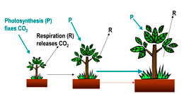
Plants absorb CO2 as part of photosynthesis. The oxygen is released back to the air (respiration), and the carbon is retained and used for growth. This natural process results in storage of carbon in plants and soil. Source: Winrock International
|